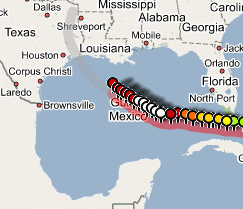
 Disaster voyeurism get’s new food. Via Google Blogoscoped I found this one about Hurricane Rita on Google Map. The Central Florida Hurricane Center shows a combination of Google Maps with hurricane tracking data, thus presenting a comprehensive view of Rita’s activities. The current placemark shows the following details:
Advisory: 23A (91383)
Position: 27.1N 91.5W
Day & Time: 09/23 8:00 AM
Wind Speed: 140 mph
Pressure: 930 mB
Movement: Northwest near 10 MPH
Hurricane Rita approaches Texas and our new internet technologies enable us to follow it’s trails near realtime. Rita likely will remain a major hurricane at landfall, which most likely will be in the early Saturday morning. But despite assistance by an enourmous computing power man is not able to predict the exact route and development of the Hurricane. This is the time to realize how helpless we are when challenging mother earth and that we should be much more careful in utilization of resources from our planet. May be it’s natures way to award a penalty to our wastefulness and pollution of the environment. Or it’s just normal, kismet or as fate willed. You are free to make up your own opinion.
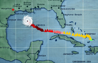 Although it’s a great disaster, the nature and power of a hurricane is fascinating and pictures and animations like the one shown at Harris County Flood Control District at the right give us the impression of being present in reality. And we should be happy. Sitting here in warm rooms in front of our screen/monitor has one big advantage – we are not there in real!
We are not threatend by hurricane rita, we have not been evacuated, we will not lose our houses and we do not risk our lives. And sure, wouldn’t you be happy if others would participate when you were in trouble by a hurricane disaster. So here comes the grand opportunity to help people in misery. Donate to the American Red Cross Disaster Relief Fund.
